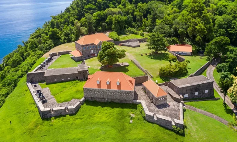
Cabrits National Park

Cabrits National Park is one of Dominica’s most iconic and ecologically significant sites, offering rich biodiversity, historical landmarks, and breathtaking coastal scenery. Situated on a picturesque peninsula in the north of Dominica, in Portsmouth. The park covers approximately 1,313 acres of tropical forests, wetlands, and marine ecosystems, all framed by the sparkling waters of the Caribbean Sea. Established in 1986, Cabrits National Park is a haven for nature enthusiasts and a site of great cultural and historical importance.
Cabrits National Park’s Geography and Natural Features
The name “Cabrits” is derived from the French word for “goat,” referencing the goats that were once abundant in the area. The park is dominated by two volcanic hills, East Cabrit and West Cabrit, remnants of an ancient volcanic crater. These lush, green hills are flanked by beautiful coastal stretches, including Douglas Bay and Prince Rupert Bay, which provide stunning views and serene beaches.
The park’s diverse landscapes include:
- Tropical Dry Forests: Unique to the park, these forests are home to rare plant species adapted to the drier conditions.
- Mangrove Swamps and Wetlands: Essential for maintaining coastal biodiversity and protecting against erosion.
- Coral Reefs and Marine Life: The surrounding marine areas are rich with coral reefs, supporting vibrant aquatic life and making it a popular spot for snorkelling and scuba diving.
Biodiversity at Cabrits National Park: Flora and Fauna
Cabrits National Park boasts an impressive array of plant and animal life. The terrestrial ecosystems are home to rare and endemic species, making it a biodiversity hotspot within Dominica.
Flora
The park features diverse vegetation types, including:
- Mahogany Trees: Towering hardwoods that add to the forest’s dense canopy.
- Ferns and Epiphytes: Thrive in the moist, shaded areas of the park.
- Mangroves: These are found along the coastline, providing critical habitats for marine species.
Fauna
Wildlife enthusiasts can encounter:
- Dominican Anole (Zandoli): A colourful lizard species endemic to the island.
- Agouti: A small, herbivorous rodent commonly seen scurrying through the underbrush.
- Birdlife: Including species like the Brown Pelican, Magnificent Frigatebird, and various migratory birds.
- Marine Life: Coral reefs teem with tropical fish, endangered sea turtles, and occasional sightings of dolphins.
Historical Significance: Fort Shirley
At the heart of Cabrits National Park lies Fort Shirley, a massive 18th-century British garrison that once played a pivotal role in the island’s colonial history. Constructed between the 1770s and 1815, the fort was a key military outpost for the British, designed to defend Dominica from French invasions.
Key Features of Fort Shirley:
- Bastions and Cannons: Overlooking Prince Rupert Bay, offering panoramic views and a glimpse into military strategy during the colonial era.
- Restored Buildings: Including officer quarters, barracks, and storage facilities, some of which have been meticulously restored.
- Interpretive Trails: Provide educational information about the fort’s history, architecture, and the soldiers who once occupied it.
Fort Shirley is also historically significant as the site of a remarkable event in 1802 when African soldiers stationed at the fort staged the West India Regiment Rebellion, one of the earliest recorded acts of resistance against British colonial rule in the Caribbean.
Adventure and Outdoor Activities
Visitors to Cabrits National Park can enjoy a wide range of activities that highlight the park’s natural beauty and historical significance:
- Hiking Trails: Well-marked trails lead through lush forests to scenic viewpoints, including the challenging hikes up East and West Cabrit.
- Snorkelling and Diving: The coral reefs around Douglas Bay are perfect for exploring underwater ecosystems.
- Bird Watching: The park’s diverse habitats attract a variety of bird species, making it a paradise for bird enthusiasts.
- Historical Tours: Guided tours of Fort Shirley offer deep insights into Dominica’s colonial past.
- Photography: Stunning landscapes, historical ruins, and rich wildlife provide endless opportunities for photographers.
Cultural Importance and Events
Cabrits National Park is more than just a natural reserve; it is a cultural hub for the local community and the island at large. The park regularly hosts events, including:
- Cultural Festivals: Celebrations of Dominican heritage with traditional music, dance, and food.
- Historical Reenactments: Bringing the stories of Fort Shirley to life.
- Eco-Tourism Events: Promoting sustainable practices and environmental awareness.
Conservation Efforts
As part of Dominica’s commitment to environmental preservation, Cabrits National Park is managed by the Forestry, Wildlife & Parks Division. Conservation efforts focus on:
- Protecting Biodiversity: Safeguarding the habitats of endemic and endangered species.
- Marine Conservation: Ensuring the health of coral reefs and marine ecosystems.
- Historical Preservation: Maintaining and restoring the structures of Fort Shirley.
- Environmental Education: Programs to raise awareness about conservation issues among locals and visitors.
Entry Fees and Regulations
Visitors must pay a modest entry fee, contributing to the park’s maintenance and conservation efforts. Regulations are in place to protect the park’s natural and historical resources, including:
- No littering or removal of natural artefacts.
- Restrictions on fishing and collecting marine life.
- Designated areas for picnicking and recreational activities.
Future Developments and Sustainability
The Government of Dominica and environmental organizations continue to invest in the sustainable development of Cabrits National Park, focusing on:
- Eco-Tourism Development: Enhancing eco-friendly facilities and promoting responsible tourism.
- Research Initiatives: Supporting scientific studies on the park’s ecosystems and historical sites.
- Community Engagement: Involving local communities in conservation efforts and park management.
A Journey through History and Beauty
Cabrits National Park is a testament to Dominica’s natural beauty and historical resilience. Its combination of lush forests, diverse wildlife, pristine beaches, and rich colonial history makes it a must-visit destination for anyone exploring the Caribbean. As Dominica positions itself as an eco-tourism leader, Cabrits National Park remains at the heart of these efforts, embodying the island’s motto: “Apres Bondie, C’est La Ter“—After God, the Earth.


