

Cabrits National Park Marine Section
Cabrits National Park Marine Section, situated in Portsmouth on Dominica’s North Coast, is integral to Cabrits National Park. This breathtaking protected area is renowned for its vibrant coral reefs and rich marine biodiversity in the Caribbean Sea, making it a top spot for snorkelling and diving enthusiasts.
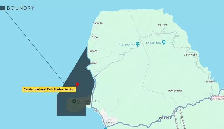
Boundaries and Accessibility
The Cabrits National Park Marine Section extends from the Lamothe River on the northwest coast, encompassing critical areas like Douglas Point, Tube Reef, and Toucari. The park’s boundaries, defined by the National Parks and Protected Areas Act, 1975, stretch to the 5-Finger Rock and are connected by significant landmarks such as the Manicou River and the Lagon River. While there is no physical boundary, visitors can access the marine section by land via the National Park Road and Bay Street north of Portsmouth or by water, with various entry points from Pointe Rounde to Capuchin. The marine section is also closely connected to Purple Turtle Beach and the Waitukubuli Sea Trail, providing additional points of interest.
Environmental and Historical Significance
This marine section, a vital part of Cabrits National Park, is crucial in preserving Dominica’s natural heritage. The area’s coral reefs, such as those found near Tube Reef, are teeming with diverse marine life, making it a popular spot for eco-tourism. The proximity of the marine section to Segment #14 of the Waitukubuli National Trail adds historical and environmental significance, offering visitors the chance to explore the island’s rich underwater ecosystems and historical landscapes. The Caribbean Sea’s natural beauty and the historical importance of nearby sites ensure that the Cabrits National Park Marine Section remains a key attraction in Dominica’s environmental and cultural conservation efforts.